
Breaking Time and Space Boundaries: GridWorld Assists "Transparent Ningxia" in Setting a New Benchmark for 3D Geology
2025-06-18Recently, a milestone moment has arrived in the field of geological informatization—the "Transparent Ningxia" 3D Geological Visualization Platform, jointly developed by GridWorld and the Geophysical and Geochemical Exploration Institute of the Ningxia Geological Bureau, has officially passed acceptance. This moment signifies that Ningxia has become the first province in western China to achieve full-region geological transparency, providing an exemplary model for the digital transformation of geological work nationwide.
Breaking New Ground: Performing a "CT Scan" of the Land
As urban construction increasingly expands underground, as resource exploration demands more precise targeting, and as geological disaster prevention requires earlier warnings, traditional geological work methods face unprecedented challenges. The emergence of "Transparent Ningxia" is timely. This full-region 3D geological model is akin to conducting a comprehensive "CT scan" of the Ningxia landscape, making every geological detail clearly visible.
Overcoming Challenges: Technological Breakthroughs in Digital Twin Land
In this battle to elevate geological information, GridWorld’s independently developed DepthInsight Geological Modeling Software demonstrated its powerful capabilities:
1. Data Fusion, Precise Replication
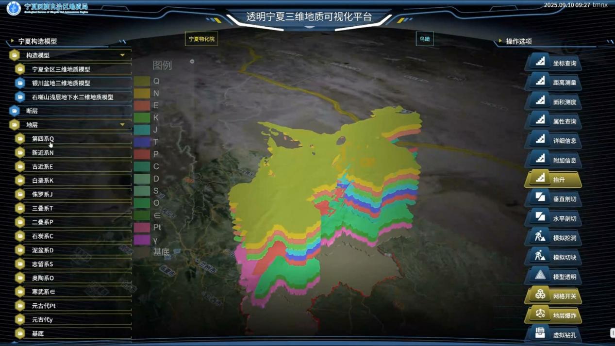
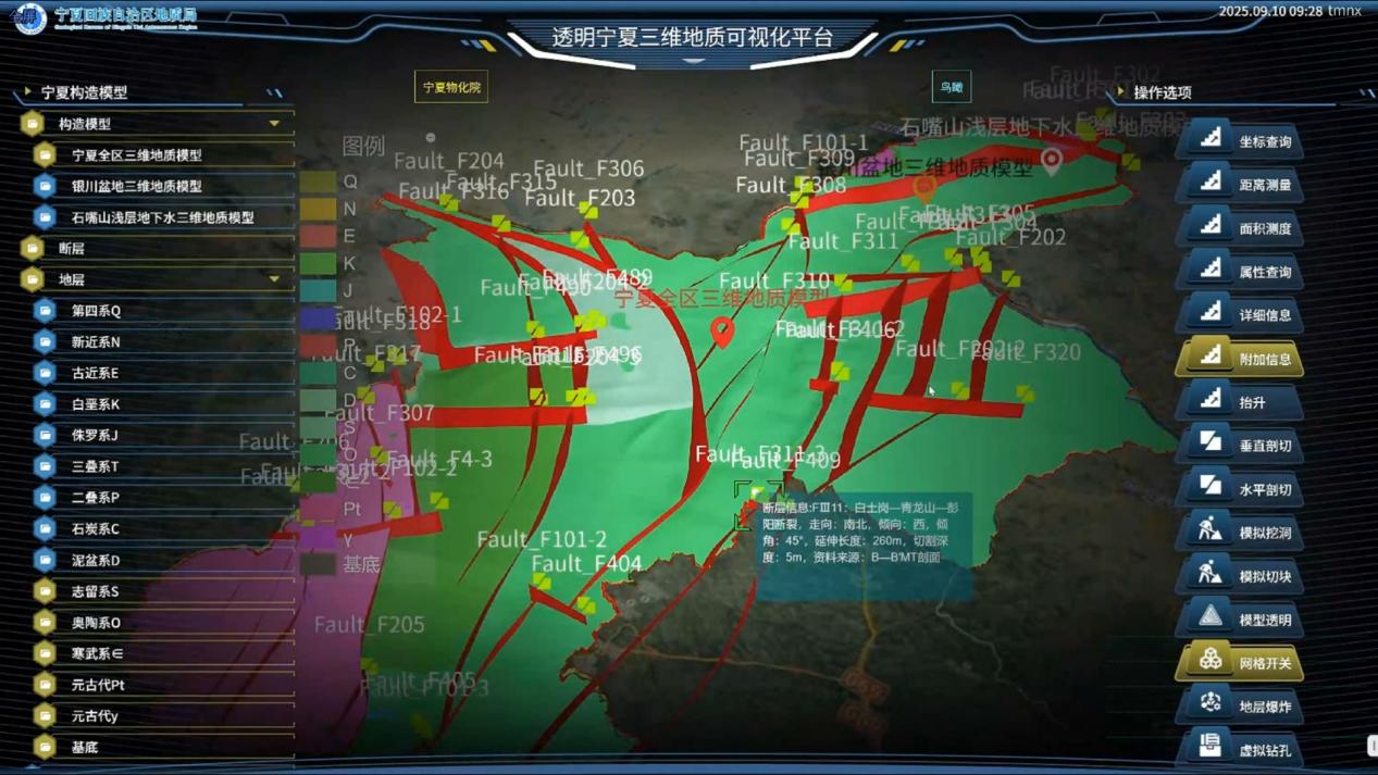
The "Transparent Ningxia" project successfully constructed a high-precision 3D geological model covering 14 standard strata and 28 major faults. From the youngest Quaternary sediments to the oldest basement rock series, the model meticulously depicts hundreds of millions of years of geological evolution, decoding the "life code" deep within the Ningxia land layer by layer.
2. Platform Empowerment, Intelligent Decision-Making
The "Transparent Ningxia" platform not only achieves integrated management of massive geological data but also breaks through the display limitations of traditional geological data. Through texture rendering, lighting settings, and interactive control features, complex geological structures become intuitive and easy to understand, providing strong support for scientific decision-making across various fields.
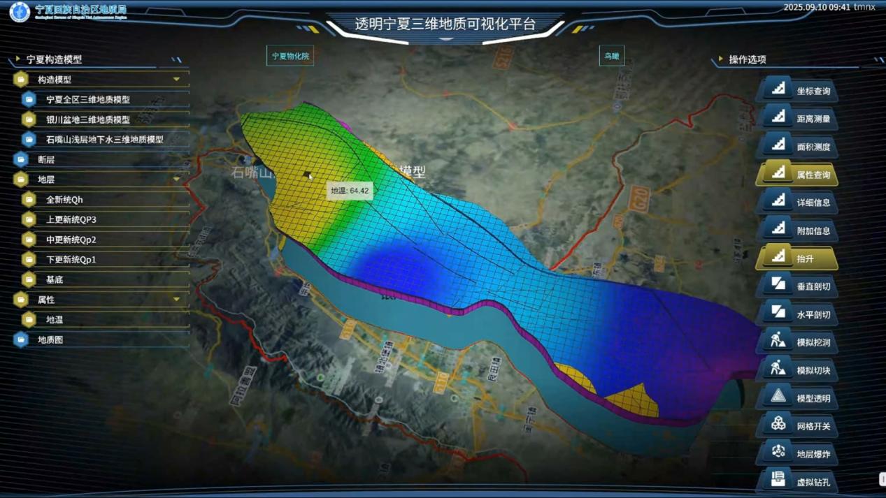
3. Geothermal Focus, Precision Navigation
Particularly noteworthy is the geothermal attribute model constructed for the Yinchuan Basin. The project clearly illustrates the distribution patterns and occurrence characteristics of geothermal resources, providing a "navigation system" for clean energy development and pioneering a new model for 3D visual evaluation of geothermal resources.
Inheritance and Legacy: A Hundred-Day Effort Forges New Digital Geological Capabilities
It is worth mentioning that while advancing technological implementation, the project team also dedicated 100 days to training, using a combination of online and offline methods, to cultivate a self-sustaining digital geological talent pool for Ningxia. This approach of "delivering both the system and the capability" ensures the platform's sustainable operation and innovative development.
Looking Ahead: GridWorld’s Dream of a "Transparent Earth"
As an innovative leader in the field of geoscience informatization, GridWorld remains committed to using digital technology to map the Earth’s veins. The success of "Transparent Ningxia" is just the beginning of the "Transparent Earth" strategy. In the future, GridWorld will continue to deepen technological innovation, promoting the application of geological digitization achievements in more fields and broader regions, contributing geological expertise to the construction of a Digital China.